From Springer Mountain Georgia to Mt. Katahdin Maine

Tuesday, October 23, 2012

NH: Lincoln, Franconia Ridge/Mt. Lincoln, and Mt. Garfield

After a quick stop at the outfitters, we picked up some snacks & beer at the grocery store before walking over to Chet's. Chet is the name of an incredible man who runs a hiker hostel. I don't know the story exactly, it is something along these lines: he was an avid hiker and was out camping and cooking on his camp stove. There was an accident with the fuel and it blew up and he was knocked unconscious and inhaled fumes and smoke. He was in a coma for a long time and recovered for the most part, but lost feeling in his legs. He's now in a wheelchair, but still very supportive of the hiking community and opens his home up to hikers. There is no charge - just donations, work-for-stay, or barter. He's a wonderful man - looks you in the eye when you speak to him and you feel like he's totally engaged in the conversation. 

While at that point, Gribley and I were traveling just the two of us (all our close friends were ahead or behind), we were in the middle of a huge hiking bubble. I called Chet to just make sure he had space for us, and he delighted me by giving me a pop quiz about the AT before agreeing to let us stay. "Where did you start?" "Well, today I started from Eliza Brook Shelter, but I started this trip on Springer Mountain, Georgia" "Wonderful, and where are you heading?" "Mt. Katahdin!" "You passed! I'd love to have you stay!" Haha he then gave us directions to the house. I felt fortunate that when we arrived, the place was pretty empty and we were able to offer a beer to Chet and share stories on the back porch, before the crowds arrived. A few more hikers showed up and we all took turns showering and then went to dinner with Lieutenant Dan. 

Henry Shires tents set up in the backyard

Bunk room & library

sleeping hiker

sign for Chet's

Chet's House

Sign in someone's yard on the way to Chet's

The next morning (8/17), we headed out for groceries and to the laundromat. I had my Patagonia down jacket the entire trip and didn't really know how to wash down at a laundromat so I had avoided that task thus far, but at that point, 1800 miles later, it was definitely time to wash it. Luckily, it was totally fine and smelled like new again! We walked back over to Chet's, packed up, and set out to hit the trail again. We stuck our thumbs out at a major intersection of Lincoln, hoping that someone in this touristy ski town would give us a ride back to the trail. Some guys working at a small outfitters across the street saw us and offered us a ride. They dropped us back at the random visitor center and we headed back to the trail, trying to figure out our plan. Liberty Springs campsite was a short 2.6 miles away, which seemed like an unimpressive day in terms of mileage, but a rainstorm was on the way and it was already 4pm. We began the steep hike up, determined to make it before the rain. We arrived just as the rains started and were greeted by a super sweet caretaker. Most of the campsites and shelters in the Whites have a fee, $8/person. The campsite was packed, I think the caretaker counted about 30 people already there, and so she put us down in a little secret spot that wasn't an official campsite, but it worked great. All the campsites in the Whites have wooden platforms built and I really didn't like setting up my tent on them, or sleeping on them. The platforms were all taken, so I was happy to sleep on the ground. The rain was consistent all night and we went to bed pretty early after eating dinner. 

I was super excited to get going in the morning - Franconia Ridge was on the itinerary for the day! Also, the caretaker informed us that Hungus & Pace were also at Liberty Springs, two of my favorite people that we hadn't seen in a few weeks. On a side note, according to Hungus, there are 4 major climbs in the Whites - Moosilauke (check), Franconia, Presidentials, and Wildcat. Lucky for us, we had already completed most of the climb up Franconia on our way up to Liberty Springs. When we set out in the morning, we climbed up Little Haystack Mountain and entered the Alpine zone. Leave No Trace ethics encourage hikers to hike and camp on durable surfaces in all situations, but in the Alpine Zone, this is especially important. 


Trail just before leaving tree-line 

View from Little Haystack Mountain

We continued hiking on up Mt. Lincoln and were gloriously reunited with Pace & Hungus. We also saw Gypsy Soul & Muck Fichigan. This day hiking was just absolutely beautiful. After our first two  days of hiking in the Whites were cloudy and overcast, we were bursting with joy at the stunning views all around. I took about a million pictures and its almost impossible to go through and edit and determine which are the best, but I've shared a few below: 


Muck Fichigan, Hungus, Pace, Gribley, Me 


We spent a long time up on Lincoln, just taking in the views and enjoying a leisurely lunch. Gypsy Soul made a big, hot soup for lunch and we laughed at the day hikers nibbling on their granola bars, looking longingly at her yummy lunch. That's the great thing about being a thru-hiker - you always have everything you need right on your back. Eventually we made our way down Lincoln, and then climbed back up to Mt. Garfield. There was a cool old structure there and we all took a break, just taking in the views. 

View from Garfield

We got going again and stopped at Garfield Shelter for water. Once we filled up, we hit the trail... except we couldn't find the trail. The path in front of us was the stream, but there were white blazes on the trees.. surely that wasn't the trail.. oh wait.. Yes, the AT was heading down a rocky path of flowing water. They really thought of every possible obstacle. So we looked each other, smiled and said here we go!

Gribley hiking down the trail/water source

Earlier that day, Hungus suggested that we camp up on Mt. Guyot. Gribley and I agreed that would be a cool place to camp, and made it our goal for the day. Coming down from Garfield, however, Pace had a few falls and decided she wanted to call it a night. Gribley and I were pretty wiped out as well, and the four of us found a little stealth spot at the intersection of a side trail. Hungus even found a teeny tiny dripping spring, and we were all able to fill up on water. It wasn't the most gorgeous campsite, but it was fun to be caught up with Pace & Hungus again, and we all shared our stories about the past few weeks. 

Monday, October 22, 2012

Beginning the Whites: Moosilauke, Wolf, and Kinsman

At 8:15am on 8/15, Gribley and I left Jeffers Brook Shelter and began our hike up Mt. Moosilauke, thus officially beginning the big, bad White Mountains. (By the way, i's pronounced MOOSE-uh-lock-ee). Warren Doyle had warned me that at this point, the trail no longer went 1/3 up, 1/3 down, and 1/3 flat - it was now all up or all down, and that  the trail ahead would not be possible to hike at a speed of 2 miles per hour (or faster - we went about 3.5mph through VA & PA). This made sense, as Mt. Moosilauke was our first mountain above treeline and our first major climb, I think since North Carolina. It is the second longest ascent on the AT, coming after Roan Mountain in NC. We would be climbing about 4,000 feet in 4 miles. I'm sure this means little to many of you. At the beginning of my trip, people would throw around elevation heights and it went right over my head. I now appreciate how many feet high a mountain is, and also the distance in which I will be climbing up it. I will inform you that 1,000 feet per mile is pretty much long, strenuous, straight up-hill climb. 

We started off with a good pace, determined to just keep putting one foot ahead of the other, as we had high hopes of still covering some good miles after Moosilauke. We ended up making pretty decent time - I think we reached the summit around 11am. The weather was foggy and cloudy, so no views, but it was INCREDIBLE to be up there without any trees, totally exposed.

Beginning the climb up Moosilauke

Gribley hiking straight up

Almost to the top - the trees are getting smaller

Wee baby trees!

Cairns marking the way

Hiking across the top

On the summit

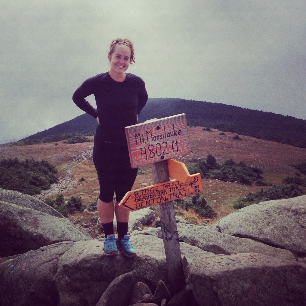
Me at the official summit, 4,802 feet

We ate a quick snack on the summit, but got moving quickly to begin the descent. Starting the climb down wasn't too bad to start. We made it to Beaver Brook Shelter for a lunch/tea break and then continued hiking down. 

Quick lunch at Beaver Brook shelter

The thing with Moosilauke - it's not just a tough climb up, it's a TREACHEROUS climb down. On the north side, you are descending straight down and 10 feet next to you in a waterfall. Gorgeuous, yes, but also incredibly terrifying and dangerous. I think I should add, however, that I especially hate going downhill. Ask my friends in "real life" - I go super slow walking down stairs. Gribley moved carefully but at a decent pace, and patiently waited while I slowly tip-toed my way down, praying I made it down in one piece. 

Note the wet wooden blocks bolted in the rocks - scary!

Immediately to the left - a waterfall


Trying to pull it together for a photo


Lo and behold, we made it down safely without any major spills, but now that it's all said and done, I can say that this part of my trip (plus a river ford in Maine) were the two most stressful, scariest parts of my whole hike. 

Anyway, we made it down to the actual Beaver Brook at the bottom of the mountain, and decided to keep with our original plan of pushing to Eliza Brook Shelter - making it a 15.6 mile day - a huge day for NH and the Whites. We crossed a highway and continued toward Mt. Wolf. The elevation profile looked flat enough, and we thought we'd make it to the shelter by dinner time. Wrong! Despite the lack of significant elevation change, NH presented a medley of technical obstacles - mud, rocks, roots, and boulders. It was impossible to set any sort of pace - each step required careful concentration and specific maneuvering. 

Technical trail

We made it to Mt. Wolf I think around 6:45, and still had 3 miles to the shelter. We were exhausted at this point, but had little water and NH trail was not very conducive to stealth spots. Not to mention, the Whites are run by the Appalachian Mountain Club (known more commonly as the Appalachian Money Club), and there are all sorts of camping regulations. Hillbilly Berry put it best when he said, "camping regulations cramp my style." Despite our wishes to stop, we mustered the energy to keep pushing to the shelter. We arrived after 9pm to an extremely crowded shelter with very limited camping options. We set up camp in a tiny space not meant for tents, but we made it work, and quickly scarfed down a pasta side and tuna, wishing we had about three more dinners each..

View from Mt. Wolf

Me & Gribs on Mt. Wolf

The next morning, August 16, we were up early. I looked up at the sky and the grey clouds seemed ominous.. With barely any cell service, I was able to text mom and see if she could pull up a weather report. The climb headed north over Kinsman (as opposed to the south-bound route) has the record amount of broken bones on the trail, and I really didn't want to climb up in a storm. On the other hand, we were practically out of food, so it was a sticky situation. Luckily mom got back to me quickly and with the good news that the rain wasn't due until 11am, which gave us enough time to get up and over Kinsman if we got moving quickly. 

The first part of Kinsman wasn't too bad and at one of the false summits, it was pretty boggy and misty. Wooden planks were laid to help hikers go through the mud - but one area was too deep and I "sunk a boot" as we called. it

Boggy pit of doom
Mud Foot


Kinsman wasn't as bad as I'd imagined. It was definitely pretty much a rock climb, using all four limbs, up and over big rock boulders. We had a blast going up - I felt like a kid just outside climbing, and it's also a pretty empowering feeling to know you can get up these insane "paths" sometimes. 


Scooby & Gribley scrambling up the rocks

At the summit

Gribley at the summit

Coming down Kinsman wasn't too bad, at least relative to Moosilauke. It was also relatively dry, and we marveled how hikers made their way in the rain. I was also thinking about hikers who have dogs, and how the dogs fare on these steep sections... must be tough for their little paws.

Anyway, we made it down just fine. We laughed as we had a break by a stream and ate our last packets of oatmeal, deciding we would "hunger strike for world peace" into Lincoln (as if we had any other option..), but it seemed more bearable (and noble) thinking about it that way.

About a mile from the road to Lincoln, we had to cross a large stream. It took us a while to figure out where the trail went - each of us going off in different directions to find a white blaze. Sometimes our lives were simplified down to a big scavenger hunt in search of blazes, which cracked me up - I'm out here on this grand adventure, but sometimes it just feels like a game. We finally realized that the trail was indeed across the river, so we made an effort to help out the hikers behind us by making arrows with sticks, and Gribley constructed several cairns. We follow white blazes, but cairns (small piles of stones) are also used as navigational devices, especially where it would be difficult to put a blaze (like exposed mountain tops that may be covered in snow or going across rivers).


After our act of goodwill, we made it to Franconia Notch. We got confused as to where we actually had to go to find the road to Lincoln. There was a small visitor center nearby with guided tours and lots of paths, so we asked some visitors which way to the center. When we arrived, we immediately devoured huge overpriced ice-cream cones, happy to be inside, as the rain we were expecting had just started pouring down. Lucky for us, other hikers had already secured a ride into town, and we were able to tag along. They dropped us at the outfitters so we could get some gear replacements. I needed a bite valve for my dromedary and Gribley needed new tips on his Leki poles. More about our time in Lincoln in the next post! 

Friday, October 19, 2012

New Hampshire // Hanover to Glencliff

After a really great time in Hanover (and temptations to stay another night), Gribley and I successfully left town about 5pm. We hiked a mile and a half up to Velvet Rocks Shelter, which is just outside Hanover. Our logic was that if we stayed in town another night, we would spend money on dinner and drinks, and then in the morning we'd want to get breakfast and coffee and then not start hiking until about noon. By leaving that night, we knew we could eat dinner on the trail, and get up and really pack away some miles the next morning. 

Velvet Rocks was nice night though. It was just me and Gribley and two older guys: Hillbilly Berry and Cheesy Turtle. Gribley met Berry back in Georgia so it was cool for them to hang out, so many miles later. We arrived with plenty of daylight left, and enjoyed a quiet night reading. 

Gribley reading and drinking tea at dusk at Velvet Rocks shelter
Sleepy faces! Breakfast at Velvet Rocks shelter. Hillbilly Berry on far left
The next morning, August 12, we really began hiking New Hampshire. I have to admit, this was one of the hardest sections of trail we experienced. The grind of the trail was becoming increasingly challenging and seemingly less rewarding at that point. I knew once I was in the Whites and in Maine, the spectacular beauty would motivate me, but the stretch from Hanover to Glencliff (the last town before the Whites) was just regular old trail, but really tough. It was in this section that I found that 10 hours was barely enough sleep, and somehow my food supply was never enough. My body was becoming exhausted. 

Anyway, we left Velvet Rocks and hiked up over Mouse Mountain. We ran into Gypsy Soul and Muck Fichigan just before the climb, where someone had left bagels as trail magic. They passed on the news that there was a huge group right behind us, that had all left Hanover that morning. This knowledge was motivation to keep hiking and try to beat the crowd. As we experienced in Vermont, a crowded trail is stressful - shelters and campsites have a limited number of tent sites, and sometimes we found ourselves setting up in less than ideal situations. Not to mention, part of the lure of hiking is the solitude and quiet time while hiking. We heard the group was heading to the Moose Mountain Shelter, so we pushed on 6 more miles to Trapper John Shelter. On the way there, we met a section hiker named Jenny who was really struggling with her gear and the terrain. She joined us for dinner, and Gribley and I shared some of the things we'd learned in the past 1750 miles. She was really grateful for our advice. 


We left Trapper John Shelter with a tough day ahead: Smart Mountain and Mt. Cube. I remember thinking, these mountains are HARD and wondering how I would fair in the Whites. We decided to push past Hexacuba Shelter as we wanted to get as close to Glencliff as possible in the morning. As always, when you skip a shelter in hopes for a stealth spot, it is quite a gamble. In Virginia and Pennsylvania, finding a flat and durable campsite on the side of the trail was no problem. Up north, these small spots were a lot harder to find and more often than not, you end up settling for a not so great spot. Gribley and I both were really running out of steam and the day was running out of light. The hike down Cube seemed to take forever and as soon as we hit flattish terrain, we pitched our tents at the first possible spot. 

The "trail" going up Smart Mtn, yes vertically up. 
Hiker trash lounging below the firepower on top of Smart. Bowser, The Georgia Boys, and Dewey
View from Smart looking out at the mountains ahead of us
Gribley hiking up Cube
Gribley on Cube
Me on Cube
View from Cube, looking south at what we hiked earlier that day
Random stealth spot. Not ideal but it will do
 The next morning, we were up and hiking early with the intention to get into Glencliff, check out the Hiker's Welcome Hostel (and possibly do laundry!), resupply, and hike out. I remember that day was pretty pleasant hiking, all the big mountains behind us until the Whites. About half a mile before Glencliff, we hiked past a hornet's next and Gribley got stung on the calf and the knee. His knee swelled up, but luckily didn't hinder his hiking too bad. We made it to the hostel, which is just off the trail in Glencliff and realized that many hikers were getting stung by the same nest. It was cool at the hostel though, lots of old timer trail "celebrities" were there, including Baltimore Jack - a jolly guy in his 40s who hiked the trail every year some 6 or 7 years in a row.

Gribley's swollen knee
Gribley stayed at the hostel icing his knee while I took the shuttle to the store to resupply for both of us. The store turned out to be a glorified gas station, as sometimes is the case. In terms of grocery stores on the AT, they are similar to how Forrest Gump describes a box of chocolates - you never know what you're gonna get. I picked out the regular items - oatmeal, pasta, granola bars.. and headed back to the hostel. Gribley's knee was a bit better and we decided to skip doing laundry so we could head on to Jeffer's Brook Shelter - the last shelter before the Whites.

Just back into the woods we recognized lots of tents - the Honeymoon Hikers, the Georgia Boys and Dewey, and Gypsy Soul and Muck Fichigan were all camping by a river and excited about starting the Whites the next morning. We chatted with everyone and then hiked on up to the shelter. We arrived around 6 and found Towelly and Cheesewater slashing around the brook. Gribley dove in, but as the temperature was dropping, I opted to stay dry and warm. We met two young guys who seemed pretty clueless and asked if we knew of any camping up on Moosilauke. We looked at them quizzically and explained that it was a major mountain, totally above treeline, and not only was camping prohibited due to fragile alpine vegetation, but it is extremely dangerous. The weather can change very quickly and you have no shelter from possible storms. We pleaded for them to just camp at the shelter and hike in the morning, like everyone else, but they shrugged off our advice and hiked on. As for us, we set up tents outside the shelter. A big group was there - the "Bros" and they had a big campfire going. I went to bed early, excited for the next day - the beginning of the Whites!
Tents set up outside Jeffers Brook Shelter

Friday, October 5, 2012

The transition begins back to "real life"

Good morning! Daystar here (now more often known as Macon), I'm in Chattanooga, slowly chipping away at putting my post-trail life back together. I've begun cleaning out my gear, and finding places for storage. It feels so strange removing myself from the items that were so heavily relied on for the past six months. All the things I needed for survival were carefully placed (or more often, forcefully smushed) in my backpack, unpacked in the evenings where I made my home for the night, and packed up again each morning. Life was so simple - hike north. Now I'm back in the world of multiples, options, and seemingly endless directions.

As much as I loved life on the trail, I am excited about the next chapter of my life. I have achieved my dreams of moving to New York City to become a magazine designer and of hiking the entire Appalachian Trail. My dream now is to own my own business and to make a living as an artist: a graphic designer and printmaker. I began this dream as a side project several years ago, and I now aspire to turn it into a full time career. I loved the movement and flow of the trail, but I now look forward to being stationery and domestic: having the time and space to bake bread, start a garden, and make art. I love working with people, and look forward to designing and printing wedding invitations, baby announcements, personal stationery, and much more. It is such a satisfying and creatively fulfilling experience to take someone's vision and create a beautiful product.

I will continue to reflect and write on this blog where I left off. I want to reminisce and describe my adventures through the White Mountains of New Hampshire, the hard trail in Southern Maine, the majestic 100 Mile Wilderness, and of course the surreal day summiting Mount Katahdin. After finishing the trail, I traveled with Gribley & Pants on Fire to the gorgeous island of Martha's Vineyard & historic Boston. This week, I drove to Damascus, VA to speak to future thru-hikers at Warren Doyle's Appalachian Trail Institute. I'm excited to share the details and photos of all these experiences in the coming weeks as I continue to get settled.

For now, I am off to my beloved state of Georgia to visit friends and continue my transition back to real life. I will drive through Chattahoochee National Forest, home of Springer Mountain, where this adventure began just over six months ago.

I wish you all a wonderful weekend. Check back next week for more posts!


Saturday, September 29, 2012

Trekked Macon

Gentle readers, it is with great fondness for all of your interest in Macon's great trek that I will be signing off this blog and bid you adieu.  Missy has left for the ATL airport to pick up Macon this afternoon at 3:00, and I wanted to make one final post.

I went back to the beginning of the blog and re-read many of the posts. The names like Hiawassi, Franklin, Gatlinburg, Clingman's Dome, Damascus, Harper's Ferry, and on and on....seem so long ago and brought back so many memories.  However, it is with very mixed emotions that it is time to acknowledge that this trek is over.  When she started, we were, how can I phrase this delicately, concerned.  We worried about her safety, we worried about her health (injury), we worried about the wisdom of starting a business and then leaving it for six months, we were worried about ourselves bidding her farewell.  What we found was a strong, gregarious, adaptable, innovative, observant, tough adventurer we had as our daughter.  We found that the trail is a wonderful sub-culture that is supportive of these kinds of dreams, that takes in for its own all types, all strata, all persuasions of folks who are bound by a common love and adventure.  Macon has made many friends, many of whom I have no doubt she will stay in touch with for many, many years to come.  There has been a status for us too, kinda like the parents of a "starter" on the team that comes with being the parents of a "thru hiker" that has been fun and served to open many conversations.

I am so looking forward to spending some time with her while she figures out the next big adventure and to hearing the stories and tales of the trail.  The layout and designer part of her will have her edit, re-format, and basically clean up this very amateurish project of love.  So, with that I sign off, but you should stay tuned as Daystar has more to say to you!

Tuesday, September 25, 2012

We made it!!

I summited today! I have completed the Appalachian Trail!! Off to celebrate, more info later :)

Sunday, September 23, 2012

No News is Good News

Gentle readers, like me you are probably on pins and needles wondering how our intrepid crew of hikers is doing, Daystar in particular.  We have not heard anything, and really don't expect to, until tomorrow or Tuesday anyway.  Macon is in a very uninhabited part of Maine with few if any cell towers around.  Here is a link to a group that maintains the trails through the 100 miles: 100 Mile Wilderness Adventures & Outfitters .  Also if you are looking for more to read while we wait, here is the link to Tater Tot's blog :Lost and loving it

And finally, here is The Chairman singing what I consider to be Macon's theme song: