At 8:15am on 8/15, Gribley and I left Jeffers Brook Shelter and began our hike up Mt. Moosilauke, thus officially beginning the big, bad White Mountains. (By the way, i's pronounced MOOSE-uh-lock-ee). Warren Doyle had warned me that at this point, the trail no longer went 1/3 up, 1/3 down, and 1/3 flat - it was now all up or all down, and that the trail ahead would not be possible to hike at a speed of 2 miles per hour (or faster - we went about 3.5mph through VA & PA). This made sense, as Mt. Moosilauke was our first mountain above treeline and our first major climb, I think since North Carolina. It is the second longest ascent on the AT, coming after Roan Mountain in NC. We would be climbing about 4,000 feet in 4 miles. I'm sure this means little to many of you. At the beginning of my trip, people would throw around elevation heights and it went right over my head. I now appreciate how many feet high a mountain is, and also the distance in which I will be climbing up it. I will inform you that 1,000 feet per mile is pretty much long, strenuous, straight up-hill climb.
We started off with a good pace, determined to just keep putting one foot ahead of the other, as we had high hopes of still covering some good miles after Moosilauke. We ended up making pretty decent time - I think we reached the summit around 11am. The weather was foggy and cloudy, so no views, but it was INCREDIBLE to be up there without any trees, totally exposed.
 |
| Beginning the climb up Moosilauke |
 |
| Gribley hiking straight up |
 |
| Almost to the top - the trees are getting smaller |
 |
| Wee baby trees! |
 |
| Cairns marking the way |
 |
| Hiking across the top |
 |
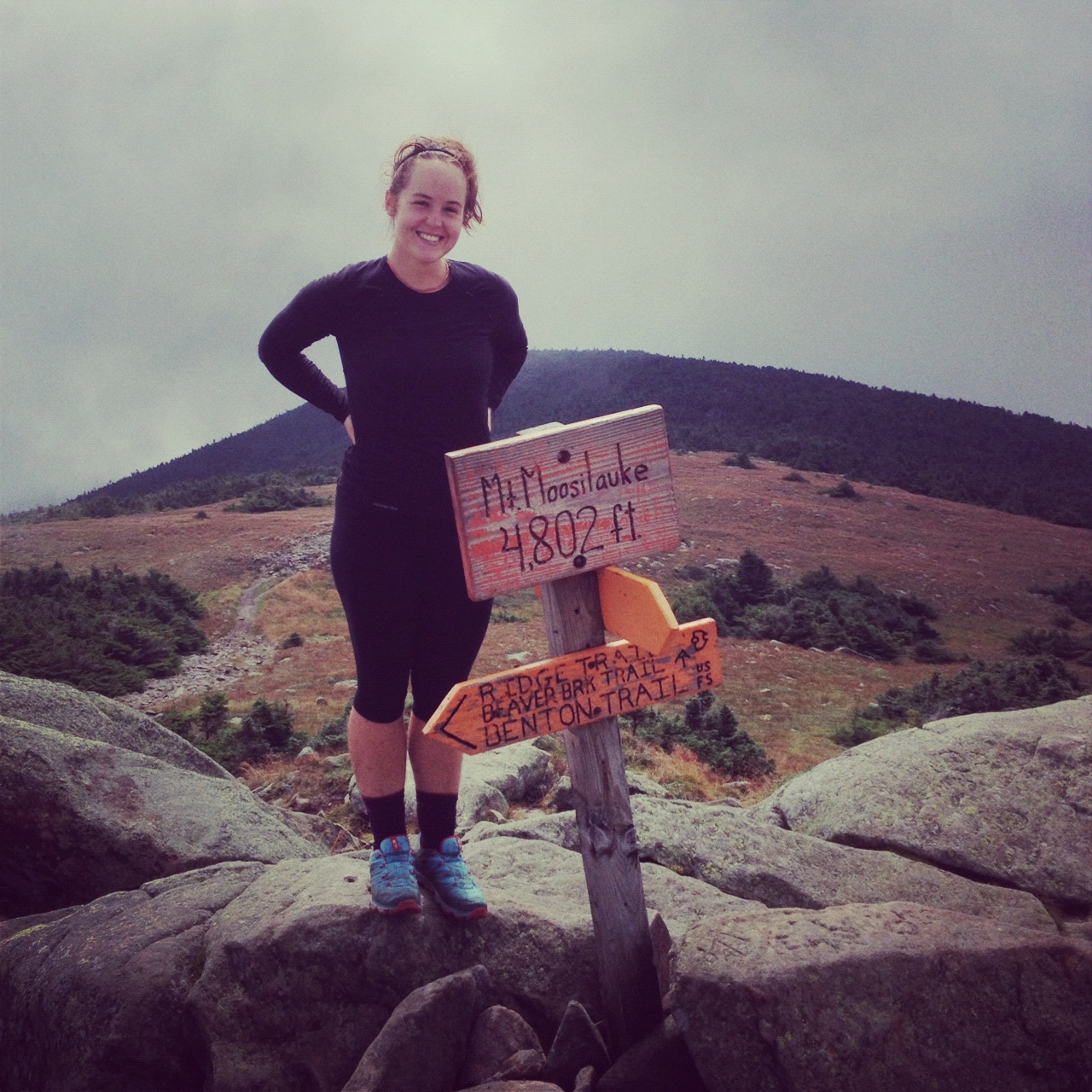
| On the summit |
 |
| Me at the official summit, 4,802 feet |
We ate a quick snack on the summit, but got moving quickly to begin the descent. Starting the climb down wasn't too bad to start. We made it to Beaver Brook Shelter for a lunch/tea break and then continued hiking down.
 |
| Quick lunch at Beaver Brook shelter |
The thing with Moosilauke - it's not just a tough climb up, it's a TREACHEROUS climb down. On the north side, you are descending straight down and 10 feet next to you in a waterfall. Gorgeuous, yes, but also incredibly terrifying and dangerous. I think I should add, however, that I especially hate going downhill. Ask my friends in "real life" - I go super slow walking down stairs. Gribley moved carefully but at a decent pace, and patiently waited while I slowly tip-toed my way down, praying I made it down in one piece.
 |
| Note the wet wooden blocks bolted in the rocks - scary! |
 |
| Immediately to the left - a waterfall |
 |
| Trying to pull it together for a photo |
Lo and behold, we made it down safely without any major spills, but now that it's all said and done, I can say that this part of my trip (plus a river ford in Maine) were the two most stressful, scariest parts of my whole hike.
Anyway, we made it down to the actual Beaver Brook at the bottom of the mountain, and decided to keep with our original plan of pushing to Eliza Brook Shelter - making it a 15.6 mile day - a huge day for NH and the Whites. We crossed a highway and continued toward Mt. Wolf. The elevation profile looked flat enough, and we thought we'd make it to the shelter by dinner time. Wrong! Despite the lack of significant elevation change, NH presented a medley of technical obstacles - mud, rocks, roots, and boulders. It was impossible to set any sort of pace - each step required careful concentration and specific maneuvering.
 |
| Technical trail |
We made it to Mt. Wolf I think around 6:45, and still had 3 miles to the shelter. We were exhausted at this point, but had little water and NH trail was not very conducive to stealth spots. Not to mention, the Whites are run by the Appalachian Mountain Club (known more commonly as the Appalachian Money Club), and there are all sorts of camping regulations. Hillbilly Berry put it best when he said, "camping regulations cramp my style." Despite our wishes to stop, we mustered the energy to keep pushing to the shelter. We arrived after 9pm to an extremely crowded shelter with very limited camping options. We set up camp in a tiny space not meant for tents, but we made it work, and quickly scarfed down a pasta side and tuna, wishing we had about three more dinners each..
 |
| View from Mt. Wolf |
 |
| Me & Gribs on Mt. Wolf |
The next morning, August 16, we were up early. I looked up at the sky and the grey clouds seemed ominous.. With barely any cell service, I was able to text mom and see if she could pull up a weather report. The climb headed north over Kinsman (as opposed to the south-bound route) has the record amount of broken bones on the trail, and I really didn't want to climb up in a storm. On the other hand, we were practically out of food, so it was a sticky situation. Luckily mom got back to me quickly and with the good news that the rain wasn't due until 11am, which gave us enough time to get up and over Kinsman if we got moving quickly.
The first part of Kinsman wasn't too bad and at one of the false summits, it was pretty boggy and misty. Wooden planks were laid to help hikers go through the mud - but one area was too deep and I "sunk a boot" as we called. it
 |
| Boggy pit of doom |
 |
| Mud Foot |
Kinsman wasn't as bad as I'd imagined. It was definitely pretty much a rock climb, using all four limbs, up and over big rock boulders. We had a blast going up - I felt like a kid just outside climbing, and it's also a pretty empowering feeling to know you can get up these insane "paths" sometimes.
 |
| Scooby & Gribley scrambling up the rocks |
 |
| At the summit |
 |
| Gribley at the summit |
Coming down Kinsman wasn't too bad, at least relative to Moosilauke. It was also relatively dry, and we marveled how hikers made their way in the rain. I was also thinking about hikers who have dogs, and how the dogs fare on these steep sections... must be tough for their little paws.
Anyway, we made it down just fine. We laughed as we had a break by a stream and ate our last packets of oatmeal, deciding we would "hunger strike for world peace" into Lincoln (as if we had any other option..), but it seemed more bearable (and noble) thinking about it that way.
About a mile from the road to Lincoln, we had to cross a large stream. It took us a while to figure out where the trail went - each of us going off in different directions to find a white blaze. Sometimes our lives were simplified down to a big scavenger hunt in search of blazes, which cracked me up - I'm out here on this grand adventure, but sometimes it just feels like a game. We finally realized that the trail was indeed across the river, so we made an effort to help out the hikers behind us by making arrows with sticks, and Gribley constructed several cairns. We follow white blazes, but cairns (small piles of stones) are also used as navigational devices, especially where it would be difficult to put a blaze (like exposed mountain tops that may be covered in snow or going across rivers).


After our act of goodwill, we made it to Franconia Notch. We got confused as to where we actually had to go to find the road to Lincoln. There was a small visitor center nearby with guided tours and lots of paths, so we asked some visitors which way to the center. When we arrived, we immediately devoured huge overpriced ice-cream cones, happy to be inside, as the rain we were expecting had just started pouring down. Lucky for us, other hikers had already secured a ride into town, and we were able to tag along. They dropped us at the outfitters so we could get some gear replacements. I needed a bite valve for my dromedary and Gribley needed new tips on his Leki poles. More about our time in Lincoln in the next post!


No comments:
Post a Comment